The Mahaweli River is Sri Lanka's longest waterway, running more than 335 km from the mist-wrapped peaks of the Central Highlands all the way to the coast near Trincomalee. It is not merely a geographical feature — the river has shaped the island's agriculture, energy grid, ancient history, and natural ecosystems for millennia. Few natural assets in Sri Lanka touch as many lives, landscapes, or livelihoods as this single river.
Where does the Mahaweli River begin and end?
The river rises in the hill country near Hatton and Nuwara Eliya, where high rainfall and cloud forest vegetation feed its upper tributaries. From there it descends steeply through the Knuckles Range foothills, passes through Kandy and the lowland plains, and eventually drains into Koddiyar Bay near Trincomalee on the east coast. Along the way it collects tributaries from across the wet and intermediate zones, making its catchment one of the largest on the island.
The transition from steep highland gorges to broad alluvial plains creates dramatically different river environments. In the upper reaches, the current is swift and the banks are forested. By the time the river reaches the North Central Province, it broadens into a slow, productive waterway surrounded by paddy fields and ancient tank systems.
Why is the Mahaweli River important for Sri Lanka's agriculture?
The river is the backbone of Sri Lanka's most ambitious irrigation network. The Mahaweli Development Programme, launched in the 1970s and 1980s, extended canals and reservoirs into the dry-zone districts of North Central and Eastern Provinces, turning large tracts of arid scrubland into productive farmland. Today, hundreds of thousands of farming families depend on Mahaweli water for paddy cultivation, vegetable growing, freshwater fishing, and livestock.
The ancient kings of Anuradhapura and Polonnaruwa understood this centuries earlier. They constructed an intricate network of tanks and channels fed by Mahaweli tributaries, many of which still function today — a testament to the sophistication of early Sri Lankan hydraulic engineering.
Which hydroelectric power stations does the Mahaweli support?
The river supplies water to four major hydroelectric facilities that together generate a substantial share of Sri Lanka's renewable electricity:
- Victoria Dam — the largest dam in Sri Lanka, located near Kandy, with a reservoir that holds around 722 million cubic metres of water.
- Randenigala Dam — downstream of Victoria, forming a reservoir that also serves as a buffer for flood management. The Randenigala Dam site itself is accessible to visitors and offers sweeping views across the reservoir.
- Rantembe Dam — the third in the cascade, immediately below Randenigala.
- Kotmale Dam — on a major tributary in the upper basin, contributing to the upper-cascade generation.
These projects also regulate seasonal flows, reducing drought stress on downstream irrigation canals during dry spells and helping moderate the severity of flooding when monsoon rains are heavy.
What wildlife and ecosystems are found along the Mahaweli?
The river corridor supports a rich mosaic of habitats. Riverine forest, grassland, and wetland fringe its banks at various points, providing shelter and food for a wide range of species. Elephants, leopards, deer, and water birds are regularly recorded in areas where the river runs through or alongside protected land.
The Horton Plains National Park, set on the plateau above the river's headwaters, protects the cloud-forest catchment that keeps the upper Mahaweli flowing. Lower down, the river's flood plains create the seasonal wetlands that many waterbirds depend on during migration and breeding seasons. Mugger crocodiles inhabit the calmer stretches of the lower basin, making the river an important habitat for this species.
How does the Mahaweli River connect to Sri Lanka's cultural history?
The river's valley was one of the first regions settled by the island's early agricultural civilisations. Ancient chronicles record the Mahaweli as a boundary marker, a source of ritual water, and a practical resource for the great monastic cities of the north. The riverside districts of Matale, Kandy, and Polonnaruwa all bear the cultural imprint of centuries of settlement along its banks.
Traditional water-cutting ceremonies (Diya-Kepeema) associated with the Mahaweli were once performed by Kandyan royalty to mark the beginning of the cultivation season, linking the river directly to religious and agricultural ritual. The Esala Perahera Festival in Kandy, though centred on the Temple of the Tooth, draws much of its symbolic meaning from the agrarian calendar that the river underpins.
What flood risks does the Mahaweli River present?
The river's large catchment area and the steep gradients of the Central Highlands mean that heavy monsoon rainfall — particularly from the south-west monsoon (May–September) and the north-east monsoon (November–January) — can cause rapid, significant rises in water levels downstream. Districts most commonly affected include Kandy, Matale, Polonnaruwa, and Trincomalee.
Key gauging stations along the river monitor flood thresholds at locations including Peradeniya, Nawalapitiya, Weraganthota, and Manampitiya. During peak flood events, some of these stations become temporarily inaccessible, underscoring the need for robust early-warning infrastructure. The lower basin, where the river reaches flatter coastal plains, is particularly prone to prolonged waterlogging because slow drainage allows floodwaters to persist for days after rainfall has stopped.
Travellers planning visits to riverside areas between October and January should check current advisories, particularly for the Polonnaruwa and Trincomalee districts.
How can travellers experience the Mahaweli River?
The river offers several accessible and rewarding experiences for visitors, ranging from easy scenic drives to active water-based activities.
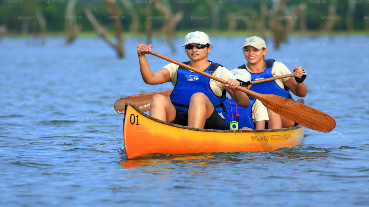
- Canoeing from Kandy: Calm stretches near Kandy are well suited to guided canoe trips, offering a water-level perspective on the forested banks and birdlife that line the river.
- Reservoir viewing: The Victoria and Randenigala reservoirs are scenic in their own right. The drive along the reservoir rim road between Kandy and Mahiyangana passes some of the finest highland scenery in the country.
- Birdwatching: The river and its adjacent wetlands attract species including kingfishers, herons, storks, and migratory waders. Early mornings on the lower reaches are particularly productive.
- Cultural touring: Combining a Mahaweli itinerary with a visit to the ancient city of Polonnaruwa places the river's agricultural legacy in its full historical context.
- Village experiences: Riverside communities in Matale and Kandy districts welcome visitors interested in traditional paddy farming, kitul-palm tapping, and rural Sri Lankan life.
What is the best time to visit the Mahaweli River region?
For most visitor activities, the period between January and April offers the most stable conditions. Rainfall is relatively low in the upper-middle reaches, reservoir levels are well managed after the north-east monsoon, and the landscape is green without being waterlogged. The Kandy district, which sits at the heart of the river's most visited section, can be enjoyable year-round, though the south-west monsoon (June to August) brings heavier rainfall to the highlands.
Those interested specifically in the river's role in agriculture should aim for the post-harvest period between February and March, when the paddy fields along the lower basin are at their most active and communities are engaged in traditional post-harvest activities.