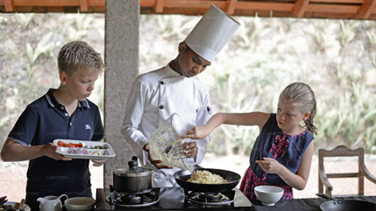
Senanayake Samudraya

Senanayake Samudraya, also known as Senanayake Reservoir, is one of the largest and most important reservoirs in Sri Lanka. Located in the Anuradhapura District, it is a significant irrigation project that serves agricultural needs in the surrounding regions.

  • Location: Wilgamuwa, North Central Province, Sri Lanka.
  • Dam Height: 33 meters (108 feet).
  • Dam Length: 1,040 meters (3,412 feet).
  • Reservoir Capacity: 127 million cubic meters of water.
  • Purpose: Primarily for irrigation, but also for flood control and water storage.
  • Significance: Key for agriculture in the dry zone of Sri Lanka and for the development of surrounding settlements.
  • Construction and Engineering:

  • The Senanayake Samudraya was constructed in the 1950s as part of a large-scale irrigation project aimed at improving agricultural productivity in the dry zone of Sri Lanka.
  • The dam was built across the Ma Oya, a river in the central part of the country, and it serves as a crucial reservoir for storing water to be used throughout the year.
  • The project was a brainchild of D. S. Senanayake, the first Prime Minister of Sri Lanka, who was deeply invested in modernizing Sri Lanka's agriculture and irrigation systems.
  • Purpose and Significance:

  • Senanayake Samudraya is primarily designed for irrigation and water management. Its reservoir helps to supply water for agricultural fields in the North Central Province and surrounding areas.
  • It plays a critical role in the Maha and Yala cultivation seasons, allowing farmers to grow crops even during the dry months when rainfall is scarce.
  • The reservoir has also contributed to reducing flooding and improving water distribution in the region, ensuring that the fields receive a steady supply of water.
  • The Dam and the Reservoir:

  • The Senanayake Dam that creates the reservoir has a length of 1,040 meters and a height of 33 meters.
  • The reservoir itself has a capacity of approximately 127 million cubic meters of water, which is critical for irrigation during the dry season.
  • The dam is an earthen structure, with the spillway designed to manage overflow during heavy rains to prevent flooding in surrounding areas.
  • Development of the Area:

  • The construction of the dam and reservoir resulted in the settlement and development of new agricultural lands around the area. It facilitated the extension of agricultural fields into areas that were previously arid or underdeveloped.
  • It has also contributed to the development of surrounding infrastructure, including roads, bridges, and communication networks, benefiting the local population in the process.
  • Ecological Impact:

  • The reservoir has become an important ecosystem and habitat for a variety of wildlife, especially birds. The surrounding area is home to wetlands that are critical for migratory species, especially during the monsoon seasons.
  • In recent years, efforts have been made to balance agricultural needs with ecological preservation in the surrounding areas, including ensuring the protection of natural habitats.
  • Cultural and Social Importance:

  • The project is considered one of the most successful irrigation and infrastructure projects in Sri Lanka’s history. It has helped alleviate poverty by enabling people in the dry zone to engage in year-round farming, improving the overall economy of the region.
  • Senanayake Samudraya also holds cultural significance, as it is a testament to the country's long history of engineering and water management, dating back to ancient systems like those built by King Parakramabahu the Great.
  • Modern Use and Future:

  • Today, Senanayake Samudraya continues to serve as a vital source of irrigation, water supply, and flood control. It is also a popular destination for visitors who appreciate both its engineering marvel and the surrounding natural beauty.
  • Ongoing maintenance and upgrades to the reservoir and dam infrastructure are essential to ensure that the project continues to function effectively, especially as climate change has altered rainfall patterns, making efficient water management more crucial than ever.
  • Over de Centrale Provincie

    De Centrale Provincie van Sri Lanka bestaat voornamelijk uit bergachtig gebied. De provincie heeft een oppervlakte van 5.674 km² en een bevolking van 2.421.148. Enkele belangrijke steden zijn Kandy, Gampola (24.730), Nuwara Eliya en Bandarawela. De bevolking is een mengeling van Singalezen, Tamils ​​en Moren.

    Zowel de heuvelhoofdstad Kandy als de stad Nuwara Eliya liggen in de Centrale Provincie, evenals Sri Pada. De provincie produceert een groot deel van de beroemde Ceylon-thee, die in de jaren 1860 door de Britten werd aangeplant nadat een verwoestende ziekte alle koffieplantages in de provincie had vernietigd. De Centrale Provincie trekt veel toeristen, met bergstadjes zoals Kandy, Gampola, Hatton en Nuwara Eliya. De Tempel van de Tand, of Dalada Maligawa, is de belangrijkste heilige plaats in de Centrale Provincie.

    Het klimaat is koel en in veel gebieden boven de 1500 meter kunnen de nachten koud zijn. De westelijke hellingen zijn erg nat, met op sommige plaatsen bijna 7000 mm regen per jaar. De oostelijke hellingen behoren tot de gematigd droge zone, omdat ze alleen regen ontvangen van de noordoostelijke moesson. De temperaturen variëren van 24 °C in Kandy tot slechts 16 °C in Nuwara Eliya, dat op 1889 meter boven zeeniveau ligt. De hoogste bergen van Sri Lanka bevinden zich in de Centrale Provincie. Het terrein is overwegend bergachtig, met diepe valleien die erdoorheen snijden. De twee belangrijkste berggebieden zijn het centrale massief en het Knuckles-gebergte ten oosten van Kandy.