Dambulla ligt in het geografische hart van Sri Lanka, ongeveer 148 km ten noordoosten van Colombo in de Noord-Centrale Provincie. Wat een generatie geleden nog een rustig dorp was, is uitgegroeid tot een van de meest strategisch belangrijke steden van het eiland — een druk verkeersknooppunt, een bloeiende landbouwmarkt en de toegangspoort tot de grootste concentratie UNESCO-werelderfgoedsites van Sri Lanka.
Waar ligt Dambulla precies, en hoe kom ik er?
De stad bevindt zich op het punt waar de snelweg Colombo–Trincomalee de weg Kandy–Anuradhapura kruist, waardoor het in het centrum van de Culturele Driehoek ligt. Kandy ligt 72 km naar het zuiden, en Colombo is ongeveer drie uur rijden. Frequente interstadsbussen verbinden het overzichtelijke centrale busstation van Dambulla met Kandy, Kurunagala, Habarana, Polonnaruwa, Anuradhapura en Sigiriya, wat het de gemakkelijkste uitvalsbasis maakt voor een bezoek aan de oude steden zonder elke nacht van accommodatie te hoeven wisselen.
Reist u zelfstandig, dan stoppen zowel privécoaches als openbare bussen bij het hoofdkruispunt. Het inhuren van een privéchauffeur via een lokale DMC geeft u de flexibiliteit om meerdere bezienswaardigheden op één dag te bezoeken, zonder afhankelijk te zijn van de schaarse plattelandsbusverbindingen.
Wat is de Gouden Rotstempelgrot, en waarom is die zo bijzonder?
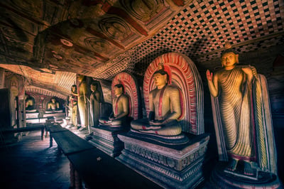
De Grotstempel van Dambulla — officieel ingeschreven op de UNESCO Werelderfgoedlijst als de Golden Rock Temple of Dambulla — is het middelpunt van elk bezoek. Het complex, gelegen ongeveer 2 km ten zuiden van het stadscentrum, is uitgehouwen in een massieve granieten rots die meer dan 160 m boven de omliggende vlakte uittorent. Vijf afzonderlijke grotkapellen herbergen zo'n 150 Boeddhabeelden, schilderingen van hindoegoden en muurschilderingen die bijna 2.100 m² aan plafonds en wanden bedekken — het grootste oppervlak aan grotschilderingen in Sri Lanka.
De grotten zijn al sinds minstens de 1e eeuw v.Chr. ononderbroken in gebruik als gebedsplaats, toen koning Valagamba hier naar verluidt zijn toevlucht zocht tijdens een periode van ballingschap voordat hij zijn troon in Anuradhapura heroverde. De religieuze en artistieke continuïteit van de site over meer dan twee millennia is wat in 1991 de Werelderfgoedstatus opleverde.
- Grot 1 (Devaraja Viharaya): Een 15 meter lange liggende Boeddha uitgehouwen in massief gesteente, met Vishnu afgebeeld in een aangrenzende nis.
- Grot 2 (Maharaja Viharaya): De grootste grot, met meer dan 50 beelden en een fraai plafondmozaïek dat het leven van de Boeddha uitbeeldt.
- Grot 3 (Maha Alut Viharaya): In opdracht van koning Kirti Sri Rajasinha in de 18e eeuw; opvallend gedetailleerde schilderingen uit de Kandyan-periode.
- Grotten 4 & 5: Kleinere kamers, nog altijd actief in gebruik voor dagelijkse eredienst.
Bezoekers beklimmen een brede rotstrap om de grotten te bereiken; de klim duurt bij een rustig tempo ongeveer 20 minuten en wordt beloond met een weids uitzicht over de vlakte richting Sigiriya Rock in de verte. Bescheiden kleding (schouders en knieën bedekt) is vereist, en schoenen moeten voor elke grot worden uitgetrokken.
Direct onder de tempelingang zijn de helder beschilderde gouden façade van het moderne Golden Temple-museum en een groot zittend Boeddhabeeld op zichzelf al bezienswaardigheden geworden. Het Dambulla Museum, gelegen ongeveer 100 m ten zuiden van de grotingang, biedt nuttige context over de archeologie en de regionale geschiedenis van de site.
Wat kan ik nog meer doen in en rond Dambulla?
Naast de grotstempel biedt Dambulla een reeks ervaringen voor reizigers die meer zoeken dan een bezoek aan een enkel monument.
Dambulla Dedicated Economic Centre
Een van de grootste groothandelsmarkten voor agrarische producten in Zuid-Azië bevindt zich aan de rand van de stad. Vroeg in de ochtend is de sfeervollste tijd om een bezoek te brengen: honderden boeren arriveren met producten variërend van chilipepers en tomaten tot tropisch fruit, en de handelsvloer biedt een authentiek inkijkje in de agrarische economie van Sri Lanka. De boeren uit de regio bevoorraden supermarkten door het hele land, en de markt is een belangrijke motor achter de moderne welvaart van Dambulla.
Dambulla International Cricket Stadium
Het Rangiri Dambulla International Cricket Stadium, met uitzicht op het stuwmeer van Dambulla, heeft Testwedstrijden, eendaagse internationals en Twenty20-duels georganiseerd. De omgeving — een verlicht veld omzoomd door rotsachtige uitstulpsels en water — is visueel markant, zelfs als er geen wedstrijd plaatsvindt. Controleer de Sri Lanka Cricket-kalender voor uw reis als u een wedstrijd wilt bijwonen.
Hiriwadunna Village Experience
Verschillende aanbieders organiseren halvedagse dorpstouren naar het nabijgelegen Hiriwadunna, met een traditionele ossenwagentocht, een boottocht op het oude irrigatiemeer en een zelfbereide lunch. Het is een van de meer authentieke plattelandservaringen vlakbij het hoofdcircuit van de Culturele Driehoek, en sluit goed aan op een ochtendbezoek aan de grotstempel.
Luchtballonvaart
Luchtballonvaarten boven de vlakte van Dambulla–Sigiriya zijn uitgegroeid tot een van de populairste zonsopgangsactiviteiten in Sri Lanka. Op hoogte vormen het vlakke agrarische landschap, de oude stuwmeren en het silhouet van Sigiriya Rock een panorama dat vanaf de grond nauwelijks te evenaren is. Vluchten zijn weersafhankelijk en vinden doorgaans plaats van ongeveer oktober tot april.
Sigiriya Village Tour
Het dorpsgebied van Sigiriya ligt slechts ongeveer 20 km van Dambulla en is gemakkelijk te combineren als halvedagse excursie. Lokale gidsen leiden wandelingen door rijstvelden, kruidentuinen en traditionele woningen, en bieden culturele context die de grote monumenten alleen niet bieden.
Wanneer is de beste tijd om Dambulla te bezoeken?
Dambulla ligt in de droge zone en kent relatief voorspelbare neerslagpatronen. De meest comfortabele periode voor toerisme is van december tot april, wanneer de noordoostmoesson is afgenomen en de temperaturen warm maar aangenaam zijn — overdag doorgaans 27–33 °C. De grotstempel kan het hele jaar door worden bezocht; de blootgestelde rotstrap wordt echter glad en onaangenaam bij hevige regen.
Het hoogseizoen (december tot maart) betekent dat de grotstempel het drukst is tussen 9 uur en 12 uur. Aankomst bij openingstijd of in de namiddag vermindert de drukte merkbaar. De schouderseizoenen mei en september kunnen voordelige periodes zijn als u flexibel bent wat het weer betreft.
Waar kan ik verblijven in Dambulla?
Het aanbod aan accommodatie rond Dambulla varieert van boetiekresorts aan het meer tot eenvoudige pensions. De meest geroemde verblijven liggen aan of vlakbij de stuwmeren van Kandalama en Dambulla, waar gasten lawaai inruilen voor natuur. Dichter bij de stad bieden diverse middenprijshotels onderdak aan individuele reizigers die gemakkelijk toegang willen tot het busstation en lokale restaurants.
Dambulla is uitstekend gelegen als uitvalsbasis voor dagtrips: Sigiriya is ongeveer 20 minuten rijden, Polonnaruwa ligt ruwweg 70 km naar het oosten en Anuradhapura is minder dan 70 km naar het noordwesten. Twee of drie nachten verblijven voorkomt de veelgemaakte fout om de Culturele Driehoek in één uitputtende dag te willen afwerken.
Welke praktische informatie heb ik nodig voor mijn bezoek?
| Detail | Informatie |
|---|---|
| Afstand tot Colombo | ~148 km (ongeveer 3–3,5 uur per auto) |
| Afstand tot Kandy | ~72 km (ongeveer 1,5–2 uur per auto) |
| Afstand tot Sigiriya | ~20 km (ongeveer 30 minuten per auto) |
| Openingstijden grotstempel | Doorgaans dagelijks 7:30–17:30 (ter plaatse bevestigen) |
| Kledingvoorschriften | Schouders en knieën bedekt; schoenen uitgetrokken bij elke grot |
| Beste maanden | December tot april |
| Dichtstbijzijnde luchthaven | Bandaranaike International Airport, Colombo (~3–3,5 uur) |
Fotograferen in de grotten is in de meeste kamers toegestaan, hoewel flitsfotografie nabij kwetsbare muurschilderingen wordt afgeraden. Een erkende gids bij de ingang kan context bieden over de iconografie, wat het bezoek aanzienlijk verrijkt — met name voor reizigers die niet vertrouwd zijn met de Theravada-boeddhistische kunst.
Plaatsen in de buurt
14 plaatsen binnen ongeveer 25 km, dichtstbijzijnde eerst.
- Dambulla Museumminder dan 1 km
- Dambulu Somavathi complexminder dan 1 km
- Dambulla Sixers (Dambulla Thunders)minder dan 1 km
- Gam Udawa Groundminder dan 1 km
- Popham's Arboretumminder dan 1 km
- Dambulu Oya Rivierminder dan 1 km
- Rangiri Dambulla International Stadium (Dambulla)1 km
- Dambulla Cave Temple1 km
- Gouden Tempel van Dambulla1 km
- Menikdena monastery complex2 km
- Pleasure Island Boat Service, Dambulla2 km
- Ibbankatuwa Wewa2 km
- Loris Watching2 km
- Ibbankatuwa megalithic burial site3 km
Verder lezen
2 pagina's over nauw verwante onderwerpen.