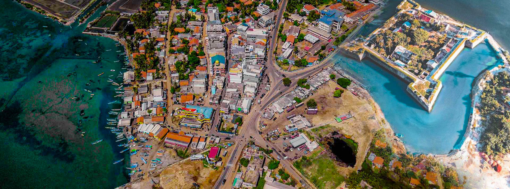
Ville de Mannar
Mannar est la principale ville du district de Mannar, dans la province du Nord du Sri Lanka. Elle est administrée par un conseil municipal. La ville est située sur l'île de Mannar, qui surplombe le golfe de Mannar, et abrite le temple historique de Ketheeswaram.
Thiru Ketheeswaram Temple
Ketheeswaram temple (Tamil: ???????????????? Tirukketisvaram is an ancient Hindu temple in Mannar, Northern Province, Sri Lanka.Overlooking the ancient Tamil port towns of Manthai and Kudiramalai, the temple has lain in ruins, been restored, renovated and enlarged by various royals and devotees throughout its history. Tirukketisvaram is one of the Pancha Ishwarams dedicated to the Hindu deity Shiva and is venerated by Shaivas throughout the continent.Throughout its history, the temple has been administered and frequented by Sri Lankan Hindu Tamils. Its famous tank, the Palavi tank, is of ancient antiquity and was restored from the ruins. Tirukketisvaram is one of the 275 Paadal Petra Sthalams of Shiva glorified in the poems of the Tevaram.
Literary and inscriptional evidence of the post classical period (300BC-1500AD) attests to the upkeep of the temple during the ancient period by kings of the Pallava, Pandyan Dynasty and Chola dynasties who contributed to its development up to the late 16th century. In 1575, Tirukketisvaram was largely destroyed by Portuguese colonials, with Pujas terminating at the shrine in 1589. Following an appeal by Arumuka Navalar in 1872, the temple was rebuilt at its original site in 1903
HistoryThe exact date of the Ketheeswaram temple's birth is not universally agreed upon.According to historian Paul Peiris, Thirukketisvaram was one of the five recognized Eeswarams of Siva in Lanka long before the arrival of Vijaya in 600 B.C. The shrine is known to have existed for at least 2400 years, with inspirational and literary evidence of the postclassical era ( 600BC – 1500AD) attesting to the shrine's classical antiquity. The buried ancient Tamil trading port of Manthottam (Mantotai/Manthai) in the Mannar District — where Ketheeswaram is located — has provided historians extant remains of the culture of the area during the ancient period. This includes the vestiges of its ancient temple tank (the Palavi tank), and the ruins of a former Hindu city built of brick, described by J.W. Bennet in 1843. During the ancient period, Mathoddam was a centre of international trade, with Greeks, Romans, Phoenicians, Arabs, Ethiopians, Persians, Chinese, Japanese, Burmese and others vying with each other to monopolise the trade of North Ceylon with Tamil traders
Mathoddam is currently viewed as the only port on the island that could be called a "buried city," with much of the ancient ruins under sand today. The existence of the Thiru-Ketheeswaram temple attests to the antiquity of the port. Mathoddam finds mention as "one of the greatest ports" on the seaboard between the island and Tamilakkam in the Tamil Sangam literature of the classical period (600 BCE – 300 CE). Hugh Nevill wrote in 1887 of the illustrious city of Mathoddam "A renowned shrine grew into repute there dedicated to one Supreme God symbolized by a single stone, and in later times restored by a Saivaite after lying long in ruins. The temple was dedicated as 'Tiru-Kethes-Waram."
One of the five ancient Iswarams of Lord Shiva on the island, Ketheeswaram joins Koneswaram (Trincomalee), Naguleswaram (Keerimalai), Tenavaram (Tevan Thurai) and Munneswaram (Puttalam) as a renowned and highly frequented pilgrimage site from before 600 BCE. In the 6th–9th century CE, the temple was glorified in the Tevaram canon, becoming one of 275 Paadal Petra Sthalams, the holiest Shiva temples on the continent. The only other Paadal Petra Sthalam from Eela Nadu (the country of the temple as named in the Tamil literature) is Koneswaram.
LegendsMythical stories related to the Indian epic Ramayana recount that Mandothari, the wife of King Ravana was from Manthai and that Mayan, the father of Mandothari and the King of Manthai built the ancient Temple of Thiruketheeswa
District de Mannar
Mannar est la capitale du district de Mannar au Sri Lanka. Le district de Mannar est situé dans le nord-ouest du Sri Lanka et constitue l’un des cinq districts administratifs de la Province du Nord. Le district couvre une superficie de 2 002 km², soit environ 3 % de la superficie totale du Sri Lanka.
Géographiquement, la majeure partie de Mannar se trouve sur le continent, dans la zone aride et sèche. Le climat se caractérise par des températures élevées et de faibles précipitations. Les températures mensuelles varient entre 26,5 °C et 30,0 °C, avec des pics généralement enregistrés entre mai et août. Mannar reçoit près de 60 % de ses précipitations pendant la mousson du nord-est, qui s’étend d’octobre à décembre.
Le relief est relativement plat et situé à basse altitude. Vers l’intérieur des terres, le terrain devient légèrement ondulé, ce qui favorise le stockage de l’eau de pluie dans des réservoirs servant à l’irrigation de la majorité des terres arables du district. Les principales activités économiques de Mannar sont l’agriculture (principalement la culture du riz), la pêche et l’élevage. Les possibilités d’emploi sont fortement saisonnières et il n’existe pas d’établissements d’enseignement supérieur dans le district.
Province du Nord
La Province du Nord est l’une des neuf provinces du Sri Lanka. Les provinces existent depuis le XIXe siècle, mais elles n’ont acquis un statut légal qu’en 1987, lorsque le 13e amendement à la Constitution de 1978 du Sri Lanka a établi les conseils provinciaux. Entre 1988 et 2006, la province a été temporairement fusionnée avec la Province de l’Est pour former la Province du Nord-Est. La capitale de la province est Jaffna.
La Province du Nord est située dans le nord du Sri Lanka et se trouve à seulement 22 miles (35 km) de l’Inde. Elle est entourée à l’ouest par le golfe de Mannar et la baie de Palk, au nord par le détroit de Palk, à l’est par le golfe du Bengale et au sud par les provinces de l’Est, du Centre-Nord et du Nord-Ouest.
La province possède plusieurs lagunes, dont les plus grandes sont la lagune de Jaffna, Nanthi Kadal, la lagune de Chundikkulam, la lagune de Vadamarachchi, la lagune d’Uppu Aru, la lagune de Kokkilai, la lagune de Nai Aru et la lagune de Chalai. La plupart des îles autour du Sri Lanka se trouvent à l’ouest de la Province du Nord. Les plus grandes îles sont Kayts, Neduntivu, Karaitivu, Pungudutivu et Mandativu.
La population de la Province du Nord était de 1 311 776 habitants en 2007. La majorité de la population est composée de Tamouls sri-lankais, avec une minorité de Maures sri-lankais et de Cinghalais. Le tamoul sri-lankais est la langue principale parlée par la grande majorité de la population. Le cinghalais est parlé par environ 1 % des habitants. L’anglais est largement parlé et compris dans les villes.