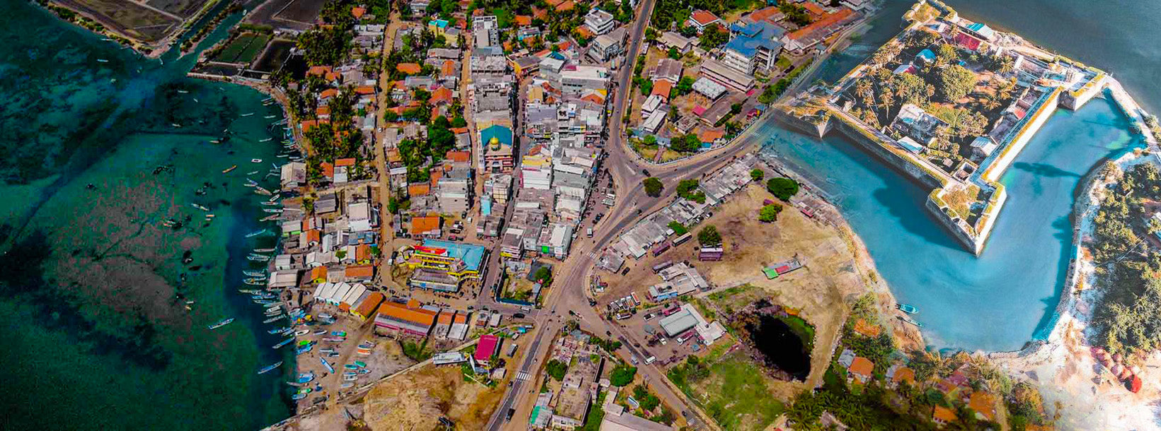
마나르 시티
마나르는 스리랑카 북부 주 마나르 지구의 중심 도시입니다. 도시 의회가 시정을 맡고 있으며, 마나르 만을 내려다보는 마나르 섬에 위치하고 있습니다. 또한 유서 깊은 케티스와람 사원이 자리하고 있습니다.
Mannar Beach
Mannar Beach, located on the northwest coast of Sri Lanka, is known for its unspoiled beauty, extensive sandy shores, and tranquil ambiance. This beach offers a unique and remote coastal experience, ideal for travelers looking to escape the more crowded tourist spots and immerse themselves in natural beauty.
Secluded and Serene
Mannar Beach features long stretches of untouched golden sand and clear, calm waters. The beach’s remote location ensures a peaceful atmosphere, perfect for those seeking solitude and relaxation away from bustling tourist areas.
Fishing and Local Culture
Fishing is an integral part of life in Mannar, and visitors can witness local fishermen at work using traditional methods. The area is rich in local culture and provides opportunities to experience the daily life and customs of the coastal communities.
Historical and Cultural Sites
Nearby Mannar Town offers several historical and cultural attractions:
- Mannar Fort: Built by the Portuguese in the 17th century and later expanded by the Dutch, this fort offers insights into the region’s colonial past and provides panoramic views of the surrounding area.
- Baobab Tree: An unusual and impressive baobab tree located in the Mannar area, which is one of the few of its kind in Sri Lanka. This tree has become a local landmark and provides a unique photo opportunity.
- Adam’s Bridge (Rama's Bridge): Although not directly on the beach, the nearby Adam’s Bridge is a historic site of interest, believed to be a chain of limestone shoals that once connected Sri Lanka to India.
Wildlife and Bird Watching
The region around Mannar Beach is known for its diverse birdlife. Birdwatchers can spot a variety of species, including migratory birds that visit the area during certain times of the year. The nearby Mannar Island is also known for its wildlife and natural beauty.
Local Cuisine
In Mannar, visitors can enjoy traditional Sri Lankan cuisine with a focus on fresh seafood. Local dishes such as fish curry, crab curry, and prawn dishes are commonly available at local eateries, offering a taste of the region’s culinary heritage.
Accommodation
Accommodation options in Mannar are relatively modest compared to more developed tourist areas. Visitors can find a range of guesthouses and small hotels that offer basic amenities and a comfortable stay. Many of these accommodations provide easy access to the beach and local attractions.
Best Time to Visit:
The best time to visit Mannar Beach is from November to April, when the weather is dry and sunny, providing ideal conditions for beach activities and exploring the local area. The monsoon season typically starts in May, bringing rain and rougher sea conditions.
만나르 지구
만나르는 스리랑카 만나르 지구의 수도입니다. 만나르 지구는 스리랑카 북서부에 위치하며 북부 주의 5개 행정 구역 중 하나입니다. 이 지구의 면적은 2,002㎢로, 스리랑카 전체 국토 면적의 약 3%를 차지합니다.
지리적으로 만나르의 대부분은 본토에 위치하며 건조 및 반건조 기후대에 속합니다. 기후는 높은 기온과 적은 강수량이 특징입니다. 월평균 기온은 26.5℃에서 30.0℃ 사이이며, 보통 5월부터 8월 사이에 최고 기온이 기록됩니다. 만나르는 연간 강수량의 약 60%를 10월부터 12월까지 지속되는 북동 몬순 기간에 받습니다.
지형은 비교적 평탄하고 해발 고도가 낮습니다. 내륙으로 갈수록 지형이 완만하게 기복을 이루며, 빗물을 저수지(탱크)에 저장하기에 유리합니다. 이 저수지들은 지구 내 경작지의 대부분에 관개용수를 공급합니다. 주요 경제 활동은 농업(주로 벼 재배), 어업, 축산업입니다. 고용 기회는 계절적 특성이 강하며, 지구 내에는 고등 교육 기관이 없습니다.
북부 주
북부 주는 스리랑카의 9개 주 중 하나입니다. 주 제도는 19세기부터 존재했으나, 1987년에 1978년 스리랑카 헌법 제13차 개정안을 통해 주 의회가 설립되면서 법적 지위를 갖게 되었습니다. 1988년부터 2006년까지 이 주는 동부 주와 일시적으로 통합되어 북동부 주를 형성했습니다. 주도는 자프나입니다.
북부 주는 스리랑카 북쪽에 위치하며 인도와는 불과 22마일(35km) 떨어져 있습니다. 서쪽으로는 만나르 만과 팔크 만, 북쪽으로는 팔크 해협, 동쪽으로는 벵골 만, 남쪽으로는 동부 주, 북중부 주, 북서부 주와 접해 있습니다.
이 주에는 여러 석호가 있으며, 가장 큰 석호로는 자프나 석호, 난티 카달, 춘디쿨람 석호, 바다마라치 석호, 우푸 아루 석호, 코킬라이 석호, 나이 아루 석호, 찰라이 석호가 있습니다. 스리랑카 주변의 대부분의 섬들은 북부 주의 서쪽에 위치해 있습니다. 가장 큰 섬은 카이츠, 네둔티부, 카라티부, 푼구두티부, 만다티부입니다.
2007년 기준 북부 주의 인구는 1,311,776명이었습니다. 인구의 대다수는 스리랑카 타밀인이며, 소수로 스리랑카 무어인과 싱할라인이 거주하고 있습니다. 스리랑카 타밀어가 주요 언어로 사용되며, 인구의 약 1%는 싱할라어를 사용합니다. 영어는 도시 지역에서 널리 사용되고 이해되고 있습니다.