Tissa Wewa (තිස්ස වැව)


Tissa wewa (also known as Tissa Wewa, Tissamaharama Lake, Tissa Wapi) is yet another destination for tourists to gain relaxation and knowledge for both physical and mental. It is a symbol of Ancient Irrigation systems of Sri lanka. And also it is one of the men made reservoirs in Anuradhapura other than Basawakkulama (Abhayagiri wewa) and Nuwara wewa. Only Abhaya wewa and Panda wewa is regarded as older than this. It is built by King Devanam Piyathissa (150-210 B.C), the predecessor of establishing Buddhism in Sri Lankan Civilization in the 3rd century. The bunt is about 11000 feet in distance and 25 feet in depth.Tisa wewa covers an area about 550 acres. Mahawansa reveals that the great King Dutugemunu went to Tissa wewa to make the rituals and observed traditions bounded with water before getting accession to the throne after defeating brutal Dravidian King Elara. The lake is located in the south west of the Anuradhapura city.
This Large irrigation system was fallen into obsolescence. But it was repaired several times even by the British government. As prescribed in H.Parker's reports, he says that the bunt has been built thickly in its original state and It may not need a maintaining. As a matter of fact, The Tissa Wewa still serves the Anuradhapura area. By the way, the Ancient Bisokotuwa made of stones was embedded with concrete. Tissa wewa was nourished with the water gained from Kala wewa. The water was supplied through the Canal, Yodha Ela. Yodha Ela is also a great creation of our ancient architectures. The architects knew that the speed of water in canals may decrease if it is moved into a zigzag shaped canal.
Thereby they used this theory to supply water for low land areas. The canals were capable of covering whole the Dry zone areas in Anuradhapura. They considered of a research to elect a suitable place to built Tissa wewa by King Devanam piya tissa. It was done under several objectives. Congruent Geographical features to imbibe water from the earth, collect and secure water from natural water resources, easier to build the dam of the tank and adjustability to face earthquakes or inundation were thoroughly considered. Thus ancient rural life style of Sri Lankans was deeply attached with watery civilization. Kings paid their utmost attention to maintain and develop the tanks, lakes and water reservoirs. They never let the people waste a single drop of water.


-
 斯里摩诃菩提
大菩提树(Jaya Sri Maha Bodhi)是斯里兰卡阿努拉德普勒马哈梅纳花园中的一棵神圣的菩提树。它是印度佛陀伽耶历史悠久的大菩提树的南枝,佛陀正是在大菩提树下证得正果。大菩提树种植于公元前288年,是世界上已知种植时间最古老的人工栽种树木。
-
 鲁万韦利塞亚
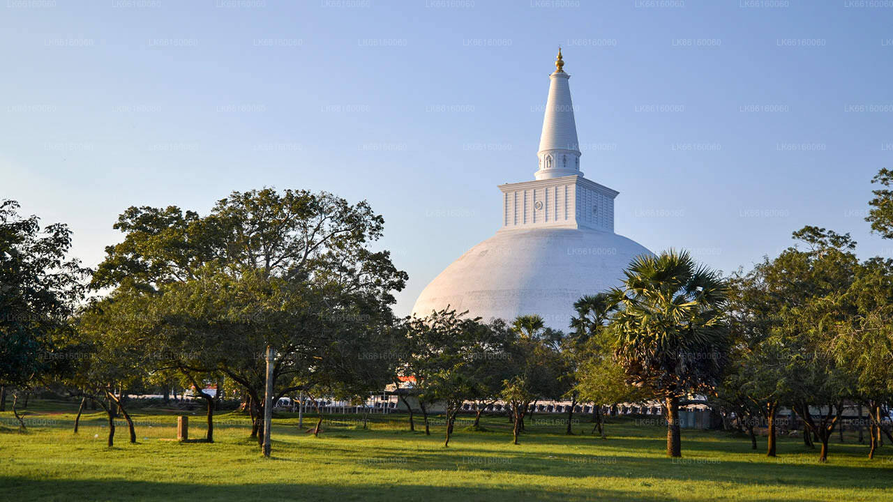
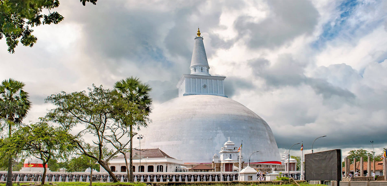
鲁万韦利大舍利塔(Ruwanweli Maha Seya),又称大舍利塔(Mahathupa),是斯里兰卡阿努拉德普勒的一座舍利塔(一种供奉舍利的半球形建筑)。塔内供奉着两夸脱(约一千克)的佛陀舍利,使其成为世界上规模最大的舍利塔。该塔由僧伽罗国王杜图伽穆努于公元前140年左右建造,他在朱罗王朝国王埃拉拉(Elāra,埃拉兰)战败后成为斯里兰卡国王。
-
 图帕拉玛亚
图帕拉玛亚托帕拉玛雅舍利塔是大德高僧(mahindagamanaya)抵达斯里兰卡后建造的第一座佛教寺庙。托帕拉玛雅舍利塔位于马哈梅纳公园的圣地,是岛上最早建造的舍利塔,其历史可追溯至德瓦南比亚·蒂萨国王(Devanampiya Tissa)统治时期(公元前247-207年)。该寺庙已被斯里兰卡政府正式认定为考古遗址。
-
 洛瓦玛哈帕亚
洛瓦玛哈帕亚(Lovamahapaya)是一座位于斯里兰卡古城阿努拉德普勒(Anuradhapura)鲁万韦利塞亚(Ruwanweliseya)和斯里摩诃波迪亚(Sri Mahabodiya)之间的建筑。由于屋顶覆有青铜瓦片,它也被称为铜宫(Brazen Palace)或洛哈普拉萨达亚(Lohaprasadaya)。在古代,这座建筑内设有食堂和布萨斋(Uposatha House)。
-
 阿拜吉里佛塔
无畏山寺(Abhayagiri Vihāra)是位于斯里兰卡阿努拉德普勒的一座主要寺院,是大乘佛教、上座部佛教和金刚乘佛教的寺院。它是世界上最大规模的遗址之一,也是斯里兰卡最神圣的佛教朝圣城市之一。
-
 祇陀林
祇陀林祇陀林舍利塔(Jetavanarama stupa)或祇陀林舍利塔(Jetavanarama stupa)是一座舍利塔,位于斯里兰卡阿努拉德普勒(Anuradhapura)的祇陀林寺(Jetavana stupa)遗址内,该寺被联合国教科文组织列为世界遗产。祇陀林舍利塔高122米(400英尺),是当时世界上最高的舍利塔,也是阿努拉德普勒国王玛哈塞纳(Mahasena,273-301年在位)建造时世界上第三高的建筑。
-
 米丽萨维蒂亚佛塔
米瑞萨维蒂佛塔是一座纪念性建筑,位于斯里兰卡古城阿努拉德普勒。杜图伽穆努国王(公元前161年至公元前137年)在击败埃拉拉国王后建造了米瑞萨维蒂佛塔。他将佛陀舍利放入权杖后,前往蒂萨维瓦沐浴,留下了权杖。
-
 兰卡拉马
兰卡拉马兰卡拉玛(Lankarama)是瓦拉甘巴国王(King Valagamba)在斯里兰卡古王国阿努拉德普勒(Anuradhapura)加尔赫巴卡达(Galhebakada)一处古迹建造的一座佛塔。这座佛塔的古代形态无人知晓,后来经过修葺。遗址显示,佛塔周围有一排排石柱,而且毫无疑问,佛塔周围曾建有一座房屋(vatadage),用于遮盖佛塔。
-
 独一无二
独一无二伊苏鲁穆尼亚(Isurumuniya)是一座佛教寺庙,位于斯里兰卡阿努拉德普勒的蒂萨水池(Tissa Wewa)附近。这座佛寺内有四座特别值得关注的雕刻,分别是《伊苏鲁穆尼亚恋人》、《象池》和《皇室家族》。古老的梅格哈吉里佛寺(Meghagiri Vihara)或梅吉里佛寺(Meygiri Vihara)目前被确认为伊苏鲁穆尼佛寺(Isurumuni Vihara)。