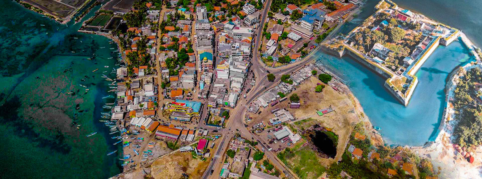
Город Маннар
Маннар — главный город округа Маннар, Северной провинции Шри-Ланки. Управление городом осуществляется городским советом. Город расположен на острове Маннар, с видом на залив Маннар, и является домом для исторического храма Кетхишварам.
Thiru Ketheeswaram Temple
Ketheeswaram temple (Tamil: ???????????????? Tirukketisvaram is an ancient Hindu temple in Mannar, Northern Province, Sri Lanka.Overlooking the ancient Tamil port towns of Manthai and Kudiramalai, the temple has lain in ruins, been restored, renovated and enlarged by various royals and devotees throughout its history. Tirukketisvaram is one of the Pancha Ishwarams dedicated to the Hindu deity Shiva and is venerated by Shaivas throughout the continent.Throughout its history, the temple has been administered and frequented by Sri Lankan Hindu Tamils. Its famous tank, the Palavi tank, is of ancient antiquity and was restored from the ruins. Tirukketisvaram is one of the 275 Paadal Petra Sthalams of Shiva glorified in the poems of the Tevaram.
Literary and inscriptional evidence of the post classical period (300BC-1500AD) attests to the upkeep of the temple during the ancient period by kings of the Pallava, Pandyan Dynasty and Chola dynasties who contributed to its development up to the late 16th century. In 1575, Tirukketisvaram was largely destroyed by Portuguese colonials, with Pujas terminating at the shrine in 1589. Following an appeal by Arumuka Navalar in 1872, the temple was rebuilt at its original site in 1903
HistoryThe exact date of the Ketheeswaram temple's birth is not universally agreed upon.According to historian Paul Peiris, Thirukketisvaram was one of the five recognized Eeswarams of Siva in Lanka long before the arrival of Vijaya in 600 B.C. The shrine is known to have existed for at least 2400 years, with inspirational and literary evidence of the postclassical era ( 600BC – 1500AD) attesting to the shrine's classical antiquity. The buried ancient Tamil trading port of Manthottam (Mantotai/Manthai) in the Mannar District — where Ketheeswaram is located — has provided historians extant remains of the culture of the area during the ancient period. This includes the vestiges of its ancient temple tank (the Palavi tank), and the ruins of a former Hindu city built of brick, described by J.W. Bennet in 1843. During the ancient period, Mathoddam was a centre of international trade, with Greeks, Romans, Phoenicians, Arabs, Ethiopians, Persians, Chinese, Japanese, Burmese and others vying with each other to monopolise the trade of North Ceylon with Tamil traders
Mathoddam is currently viewed as the only port on the island that could be called a "buried city," with much of the ancient ruins under sand today. The existence of the Thiru-Ketheeswaram temple attests to the antiquity of the port. Mathoddam finds mention as "one of the greatest ports" on the seaboard between the island and Tamilakkam in the Tamil Sangam literature of the classical period (600 BCE – 300 CE). Hugh Nevill wrote in 1887 of the illustrious city of Mathoddam "A renowned shrine grew into repute there dedicated to one Supreme God symbolized by a single stone, and in later times restored by a Saivaite after lying long in ruins. The temple was dedicated as 'Tiru-Kethes-Waram."
One of the five ancient Iswarams of Lord Shiva on the island, Ketheeswaram joins Koneswaram (Trincomalee), Naguleswaram (Keerimalai), Tenavaram (Tevan Thurai) and Munneswaram (Puttalam) as a renowned and highly frequented pilgrimage site from before 600 BCE. In the 6th–9th century CE, the temple was glorified in the Tevaram canon, becoming one of 275 Paadal Petra Sthalams, the holiest Shiva temples on the continent. The only other Paadal Petra Sthalam from Eela Nadu (the country of the temple as named in the Tamil literature) is Koneswaram.
LegendsMythical stories related to the Indian epic Ramayana recount that Mandothari, the wife of King Ravana was from Manthai and that Mayan, the father of Mandothari and the King of Manthai built the ancient Temple of Thiruketheeswa
Округ Маннар
Маннар является столицей округа Маннар на Шри-Ланке. Округ Маннар расположен на северо-западе Шри-Ланки и является одним из пяти административных округов Северной провинции. Площадь округа составляет 2002 км², что примерно равно 3% от общей площади Шри-Ланки.
Географически большая часть Маннара находится на материке в засушливой и полузасушливой климатической зоне. Климат характеризуется высокими температурами и низким уровнем осадков. Среднемесячные температуры варьируются от 26,5°C до 30,0°C, при этом самые высокие температуры обычно фиксируются с мая по август. Маннар получает около 60% осадков в течение северо-восточного муссона, который длится с октября по декабрь.
Местность в округе в основном плоская и расположена на низких высотах. Внутренние районы немного холмистые, что способствует накоплению дождевой воды в резервуарах, которые обеспечивают основную часть ирригации для пахотных земель округа. Основными экономическими занятиями в Маннаре являются сельское хозяйство (в основном выращивание риса), рыболовство и животноводство. Возможности для трудоустройства сильно зависят от сезона, и в округе нет учреждений высшего образования.
Северная провинция
Северная провинция является одной из девяти провинций Шри-Ланки. Провинции существовали с XIX века, но юридический статус они получили только в 1987 году, когда 13-я поправка к Конституции Шри-Ланки 1978 года установила провинциальные советы. С 1988 по 2006 год провинция была временно объединена с Восточной провинцией для формирования Северо-Восточной провинции. Столицей провинции является Джафна.
Северная провинция расположена на севере Шри-Ланки и находится всего в 22 милях (35 км) от Индии. Провинция ограничена с запада заливом Маннар и заливом Палк, на севере — Палькским проливом, на востоке — Бенгальским заливом, а на юге — Восточной, Центрально-Северной и Северо-Западной провинциями.
В провинции находится несколько лагун, среди которых крупнейшими являются лагуна Джафна, Нанти-Кадал, лагуна Чундиккулам, лагуна Вадамараччи, лагуна Уппу-Ару, лагуна Коккилай, лагуна Най-Ару и лагуна Чалай. Большинство островов вокруг Шри-Ланки находится на западе Северной провинции. Крупнейшими островами являются Кейтс, Недунтиву, Карайтиву, Пунгудутиву и Мандативу.
По состоянию на 2007 год население Северной провинции составляло 1 311 776 человек. Большинство населения составляют тамилы Шри-Ланки, с меньшинством, состоящим из мавров Шри-Ланки и сингалов. Тамильский язык является основным языком, на котором говорит большинство населения. Сингальский язык используется около 1% населения. Английский язык широко используется и понимается в городах.