تقع دامبولا في قلب سريلانكا الجغرافي، على بُعد نحو 148 كم إلى الشمال الشرقي من كولومبو، في المقاطعة الشمالية الوسطى. وما كان قرية هادئة قبل جيل، تحوّل اليوم إلى واحدة من أكثر المدن أهمية استراتيجية في الجزيرة — ملتقى طرق مزدحم، وسوق زراعي نشط، وبوابة إلى أعظم تركّز لمواقع التراث العالمي لليونسكو في سريلانكا.
أين تقع دامبولا بالضبط، وكيف يمكنني الوصول إليها؟
تحتل المدينة النقطة التي يلتقي فيها طريق كولومبو–ترينكومالي السريع بطريق كاندي–أنورادهابورا، مما يجعلها في مركز المثلث الثقافي. تبعد كاندي 72 كم إلى الجنوب، وتبعد كولومبو نحو ثلاث ساعات بالسيارة. تربط حافلات منتظمة بين الخدمات بين محطة الحافلات المركزية المنظّمة في دامبولا وكل من كاندي وKurunagala وهاباراناً وبولونارووا وأنورادهابورا وسيغيريا، مما يجعلها القاعدة المثلى لجولة المدن الأثرية دون الحاجة إلى تغيير مكان الإقامة كل ليلة.
إن كنت مسافراً بشكل مستقل، تتوقف كل من الحافلات الخاصة والعامة عند التقاطع الرئيسي. يمنحك استئجار سائق خاص عبر وكالة سياحية محلية مرونة زيارة عدة مواقع في يوم واحد دون الاعتماد على خدمات الحافلات الريفية غير المنتظمة.
ما هو معبد الكهف الصخري الذهبي، ولماذا يكتسب هذه الأهمية؟
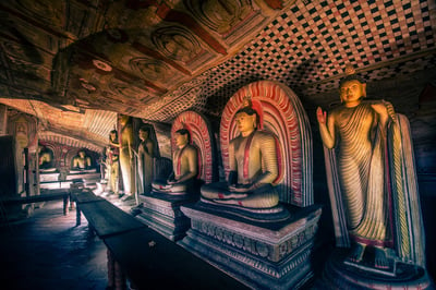
يُعدّ معبد كهف دامبولا — المُدرَج رسمياً على قائمة التراث العالمي لليونسكو باسم المعبد الصخري الذهبي لـ دامبولا — محور أي زيارة. يقع المجمع على بُعد نحو 2 كم جنوب مركز المدينة، وهو منحوت في نتوء صخري جرانيتي ضخم يرتفع أكثر من 160 م فوق السهول المحيطة. تضم خمسة أضرحة كهفية منفصلة نحو 150 تمثالاً للبوذا، ورسومات لآلهة هندوسية، ولوحات جدارية تغطي ما يقارب 2,100 م² من الأسقف والجدران — أكبر مساحة لرسوم الكهوف في سريلانكا.
لا تزال الكهوف في استخدام مستمر كمكان للعبادة منذ القرن الأول قبل الميلاد على الأقل، حين يُقال إن الملك Valagamba لجأ إليها خلال فترة منفاه قبل استعادة عرشه في أنورادهابورا. وما أكسب الموقع مكانة التراث العالمي عام 1991 هو هذا الاستمرار الديني والفني عبر أكثر من ألفي عام.
- الكهف 1 (Devaraja Viharaya): تمثال بوذا راقد بطول 15 متراً منحوت من الصخر الصلب، مع تصوير Vishnu في تجويف مجاور.
- الكهف 2 (Maharaja Viharaya): أكبر الكهوف، يضم أكثر من 50 تمثالاً ولوحة سقفية رائعة تصوّر حياة البوذا.
- الكهف 3 (Maha Alut Viharaya): أُنشئ بأمر من الملك Kirti Sri Rajasinha في القرن الثامن عشر؛ ويتميز بلوحات دقيقة التفاصيل من حقبة Kandyan.
- الكهفان 4 و5: حجرات أصغر حجماً، لا تزال تُستخدم يومياً في العبادة.
يصعد الزوار درجاً صخرياً عريضاً للوصول إلى الكهوف؛ ويستغرق الصعود نحو 20 دقيقة بخطى مريحة، ويُكافئهم بإطلالات بانورامية خلّابة على السهول باتجاه صخرة سيغيريا في الأفق البعيد. يُشترط ارتداء ملابس محتشمة (تغطية الكتفين والركبتين)، ويجب خلع الأحذية قبل دخول كل كهف.
أسفل مدخل المعبد مباشرةً، أصبحت الواجهة الذهبية الملوّنة بألوان زاهية لمتحف المعبد الذهبي الحديث وتمثال بوذا جالس كبير معالم بارزة في حد ذاتها. أما متحف دامبولا، الواقع على بُعد نحو 100 م جنوب مدخل الكهف، فيوفر سياقاً مفيداً حول آثار الموقع وتاريخ المنطقة.
ما الذي يمكنني فعله في دامبولا وحولها؟
إلى جانب معبد الكهف، تقدم دامبولا مجموعة من التجارب التي تناسب المسافرين الراغبين في أكثر من مجرد زيارة نصب أثري واحد.
المركز الاقتصادي المخصص في دامبولا
يعمل على أطراف المدينة أحد أكبر أسواق الجملة الزراعية في جنوب آسيا. الصباح الباكر هو الوقت الأكثر حيوية للزيارة: يصل المئات من المزارعين بمنتجاتهم التي تتراوح بين الفلفل الحار والطماطم والفواكه الاستوائية، ويُمثّل قاع التداول نافذة حقيقية على الاقتصاد الزراعي في سريلانكا. يورّد مزارعو المنطقة منتجاتهم لمحلات السوبر ماركت في أنحاء البلاد، وتُعدّ السوق من أبرز محركات الازدهار الحديث لـ دامبولا.
ملعب دامبولا الدولي للكريكيت
استضاد ملعب Rangiri دامبولا الدولي للكريكيت المُطلّ على خزان دامبولا مباريات اختبارية وأحادية اليوم وعروض Twenty20. ويتميز الموقع — ملعب مضاء بالكهرباء تحاذيه النتوءات الصخرية والمياه — بجماليات بصرية مميزة حتى في غياب المباريات. تحقق من جدول سريلانكا Cricket قبل رحلتك إن كنت ترغب في حضور مباراة.
تجربة قرية Hiriwadunna
ينظّم عدد من مشغّلي الجولات رحلات نصف يوم إلى قرية Hiriwadunna القريبة، تجمع بين ركوب عربة الثيران التقليدية، ورحلة بالقارب على خزان الري الأثري، وغداء منزلي الطهو. وتُعدّ من أكثر التجارب الريفية الأصيلة التي يمكن الوصول إليها بالقرب من الدائرة الرئيسية للمثلث الثقافي، وتتكامل جيداً مع صباح يُقضى في معبد الكهف.
رحلات المناطيد
رحلات المناطيد فوق سهول دامبولا–سيغيريا باتت من أكثر أنشطة شروق الشمس شعبيةً في سريلانكا. من الارتفاع، يتشكّل مشهد بانورامي يصعب مجاراته من الأرض: ألواح أراضٍ زراعية مسطّحة، وخزانات أثرية، وصخرة سيغيريا الشامخة في الأفق. تخضع الرحلات لأحوال الطقس وتعمل عادةً من أكتوبر حتى أبريل.
جولة قرية سيغيريا
تقع منطقة قرية سيغيريا على بُعد نحو 20 كم فحسب من دامبولا، ويسهل دمجها كرحلة نصف يوم. يقود المرشدون المحليون مشياً عبر حقول الأرز وحدائق البهارات والمنازل التقليدية، مما يمنح سياقاً ثقافياً لا توفره المعالم الكبرى وحدها.
ما هو أفضل وقت لزيارة دامبولا؟
تقع دامبولا في المنطقة الجافة وتتميز بأنماط هطول أمطار منتظمة نسبياً. تمتد الفترة الأكثر راحةً للسياحة من ديسمبر حتى أبريل، حين يخفّ موسم الرياح الموسمية الشمالية الشرقية وتكون درجات الحرارة دافئة ومعتدلة — تتراوح عادةً بين 27 و33 درجة مئوية خلال النهار. يمكن زيارة معبد الكهف طوال العام؛ غير أن الدرج الصخري المكشوف يصبح زلقاً وغير مريح في أوقات الأمطار الغزيرة.
في موسم الذروة السياحية (ديسمبر إلى مارس) يشهد المعبد أكبر حشد بين الساعة 9 صباحاً والظهر. الوصول عند وقت الافتتاح أو في منتصف فترة ما بعد الظهر يقلّل الازدحام بشكل ملحوظ. كما قد تكون أشهر الكتف في مايو وسبتمبر خياراً ذا قيمة جيدة إن كنت مرناً تجاه أحوال الطقس.
أين أقيم في دامبولا؟
تتفاوت خيارات الإقامة حول دامبولا بين منتجعات بوتيك تطل على البحيرات وبيوت ضيافة بسيطة. تتربّع أبرز العقارات على ضفاف خزانَي Kandalama ودامبولا أو بالقرب منهما، حيث يستبدل النزلاء ضجيج المدينة بمناظر طبيعية خلّابة. وأقرب إلى المدينة، تستقبل مجموعة من الفنادق متوسطة المستوى المسافرين المستقلين الراغبين في سهولة الوصول إلى محطة الحافلات والمطاعم المحلية.
تتميز دامبولا بموقعها المثالي كقاعدة لرحلات يومية: سيغيريا على بُعد نحو 20 دقيقة بالسيارة، وبولونارووا على بُعد نحو 70 كم شرقاً، وأنورادهابورا أقل من 70 كم إلى الشمال الغربي. إقامة ليلتين أو ثلاث تُجنّبك الخطأ الشائع المتمثل في اجتياز المثلث الثقافي في يوم واحد مرهق.
ما المعلومات العملية التي أحتاجها قبل الزيارة؟
| التفاصيل | المعلومات |
|---|---|
| المسافة من كولومبو | ~148 كم (نحو 3–3.5 ساعات بالسيارة) |
| المسافة من كاندي | ~72 كم (نحو 1.5–2 ساعة بالسيارة) |
| المسافة من سيغيريا | ~20 كم (نحو 30 دقيقة بالسيارة) |
| أوقات عمل معبد الكهف | عادةً من 7:30 صباحاً حتى 5:30 مساءً يومياً (يُرجى التأكد محلياً) |
| قواعد اللباس | تغطية الكتفين والركبتين؛ وخلع الأحذية عند كل كهف |
| أفضل الأشهر | ديسمبر حتى أبريل |
| أقرب مطار | مطار Bandaranaike الدولي، كولومبو (~3–3.5 ساعات) |
التصوير داخل الكهوف مسموح به في معظم الحجرات، وإن كان استخدام الفلاش قرب اللوحات الجدارية الحساسة غير محبّذ. يمكن لمرشد مرخّص عند المدخل أن يقدم شرحاً للرموز الأيقونية يُثري الزيارة بشكل ملحوظ، ولا سيما للزوار غير المألوفين بالفن البوذي التيرافادي.
أماكن قريبة
أماكن ضمن نحو 25 كم (14)، الأقرب أولاً.
- Dambulla Museumأقل من 1 كم
- Dambulu Somavathi complexأقل من 1 كم
- Dambulla Sixers (Dambulla Thunders)أقل من 1 كم
- Gam Udawa Groundأقل من 1 كم
- Popham's Arboretumأقل من 1 كم
- Dambulu Oya Riverأقل من 1 كم
- Rangiri Dambulla International Stadium (Dambulla)1 كم
- Dambulla Cave Temple1 كم
- معبد دامبولا الذهبي1 كم
- Menikdena monastery complex2 كم
- Pleasure Island Boat Service, Dambulla2 كم
- Ibbankatuwa Wewa2 كم
- Loris Watching2 كم
- Ibbankatuwa megalithic burial site3 كم
قراءات ذات صلة
صفحات عن مواضيع وثيقة الصلة: 2.